McConkie Ranch Petroglyph – Utah
For rock art hunters, Utah offers a veritable playground to explore, with hundreds, if not thousands of sites open to discovery. Some locations are well known, while others take a significant effort in both time and research to find. And I like many avid rock art enthusiats tend to keep the lesser known sites close to the vest. I do it for two reasons…half the fun is the research and discovery process. Nothing that is handed to you is as rewarding as finding it yourself. And second, there is little doubt that some among us hold this ancient art in less regard than others. Which has led to widespread vandalism of some of the more well known and easily accessible sites. With that, plenty can be said that will help those interested in exploring the wilds of Utah, and discovering a little bit of the history carved and painted on its sandstone walls.
Pictographs vs. Petroglyphs
What is the difference between a pictograph and petroglyph?. The answer lies in the tools used to create the art. Pictographs are essentially paintings, using varies pigments that produce different colors. Ochre was a widely used example that produces earthy shades of orange and red. But explore enough and you’ll find other colors like white, yellow, blue and green. On the other hand, Petroglyph were created by artists that used rocks and other blunt instruments to chip a design out of their sandstone canvas.
In my experience different tribes at different periods of time seemed to favor one style over the other. But it would be incorrect to say that pictographs were created by one group of Indians, and petroglyphs by another. As there example of both styles being used at the same time, and taking on the same artistic characteristics and subjects.
What is the rock art telling us?
At this point nobody knows precisely, and chance are good we never will. There is no equivalent to the Rosetta Stone in North American archaeology, and even if one were found, the rock art one finds in Utah and throughout the American Southwest is spread over such a vast period of time, and many different cultures that one translation wouldn’t fit them all.That being said, I don’t think we need to look farther than our own lives to get a sense of what the ancient Native Americans were recording in the sandstone. Like us they were human beings with aspirations, struggles, and questions about their place in the Universe.
If you look closely enough at the rock art and make some educated guesses you will see at least three different things.
The Natural World
There are repeated depictions of animals found in the real world. Bighorn sheep, snakes, buffalo, deer, elk and lizards. No doubt the Indians saw these as either a food source, a predator to be wary of, or both. If you look at the Native American mythology of today you can also imagine these creatures taking on a spiritual or earthly mythological component. The oral traditions of the Raven and Coyote as a trickster that one sees in modern tribes is a good example.
The Spirit World
As noted above, there also seems to be a clear spiritual, or mythological component to the rock art that depicts creatures and anthropomorphic figures that are clearly not realistic representations of something found on Earth in the present or during the period ancient Indian tribes lived in the West. No doubt these creatures find their origin in dreams, oral stories and spiritual beliefs about the world and the broader universe. Similar examples of such creatures can be found in the mythology of ancient Greece, the Norse, the Irish, etc.
The Celestial World
Finally, research has demonstrated that certain markings left behind were related to celestial events and observations. Such as arrows and other markers painted or carved onto rock faces where the sunlight only falls on key days of the astronomical calendar, such as the Summer and Winter Solstices, and the Spring and Fall Equinoxes. These markings alone tell us the Native Americans were keen observers of the night sky, and knew lunar, solar and constellation cycles well.
Different Rock Art Styles/Traditions
At least three major groups were involved in producing the rock art found in Utah.
Archaic Indian Period (7500 B.C. to 300 A.D.?)
One of the major producers of pictograph rock art in Utah were a group of hunters and gathers known as Archaic Indians that lived in Utah from about 7500 B.C. until possibly as recent as 300 A.D. The art they left behind is known as the Barrier Canyon Style, whose name is derived from Barrier Canyon (now called Horseshoe Canyon) which lies to the west of Moab in an extension of Canyonlands National Park. Dating estimates for BCS seem to vary widely and are based on the difficult task of radiocarbon dating pigments and rock falls.
Fremont /Anasazi Indian Period (100 A.D.-1300 A.D.)
While the Fremont and the Anasazi were very distinct groups, they shared a number of similar characteristics, including a semi-nomadic lifestyle that incorporated village life and farming with active hunting and gathering. They also share a common time frame, which is why I group them together here. In general, I think it can be said that petroglyphs were there preferred form of expression, but pictographs including handprint displays have been attributed to them.
Ute Indian Period (1300 A.D. – 1880 A.D.)
The Ute Indian rock art is best distinguished from earlier art by the depiction of horses and their riders, as well as other more realistic depictions of animals, humans, etc. While horses were once native to North America they became extinct eons before humans arrived. Their depiction in recent petroglyphs provides a fairly precise date no earlier than the arrival of the Spanish, who were the first to bring horses back to the Western Hemisphere.
Popular Utah Rock Art Sites
Sego Canyon
I mention Sego Canyon first because its a bit unique in my experience, offering three distinct displays of rock art from the time periods described above. This allows the visitor to easily compare the different styles. Sego Canyon is located north of Moab and close to Utah’s border with Colorado off I-70. Just find Thompson Springs north of the highway, and follow its main road toward the Book Cliffs. Signs will direct you the rest of the way. Keep in mind that while part of the land containing petroglyphs is owned by the BLM, some are also on private land.
Horseshoe Canyon
This canyon contains what has been described as the “Michelangelo” of North American rock art – the Great Gallery. Within Horseshoe Canyon (once called Barrier Canyon) resides the largest and best-preserved examples of the Barrier Canyon Style, in a series of rock art panels. The Great Gallery the largest of the panels and over 200 feet in length, has anthropomorphs as tall as 7 feet and more than a half dozen of a similar height. The access point to Horseshoe Canyon is a dirt road on the opposite side of the highway from the entrance to Goblin Valley. Look for signs to Horseshoe Canyon. In dry weather, the road can be traveled by any well-maintained vehicle with proper precaution. The road is about 30 miles, and the hike into the canyon is 7 miles round trip. The best time to enter the canyon is in the early morning, this will help you to avoid most of the afternoon heat when you exit, and the sun should be in a good spot for photograph most of the panels.
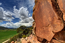
McConkie Ranch (Dry Fork Canyon)
McConkie Ranch is to the Fremont Petroglyph legacy what Horseshoe Canyon was to the Archaic Indians. Hands down this along with Horseshoe Canyon are the most amazing petroglyph/pictograph sites I have ever visited. The petroglyphs are varied, detailed, pristine, and in some cases very large. However, unlike the other sites mentioned here, this one is entirely on private land, which for now remains open to those who respect the site and its owners. However, as was indicated to me that could change at any time. So if you haven’t been here before I highly recommend visiting sooner rather than later. And when you go, if you are lucky you might get to see their collection of arrowheads, spear points, baskets, and metates.
Newspaper Rock
Newspaper Rock is probably the best known and most widely photographed petroglyph panel in the United States. It features an array of different creatures, anthropomorphs, and symbols from a variety of different cultures. The Archaic Indians, Fremont, Anasazi, Navajo and other Ancestral Puebloan cultures have all visited the site and left their mark over the ages. This particular panel is located on the southern edge of Canyonlands, along SR211 which leads to the Needles section of the park.
Rochester Panel
This panel is mostly of Fremont origin but also displays art from other tribes, explorers, Mormon pioneers and unfortunately tourists. The acts of the latter though should not dissuade you from a visit, as it is equal in caliber to Newspaper Rock in the amount and variety of art displayed in one spot. The panel is located just west of the San Rafael swell and east of the town of Emery.
Nine Mile Canyon
Nine Mile Canyon, located just north of Wellington in central Utah, was a vast artistic canvas for Fremont and Ute Indians. Its claim to fame is the sheer quantity of rock art that can be found along the canyon’s 46-mile length. To date over 1000 archaeological sites have been cataloged, including petroglyphs, dwelling ruins, and grain stores. Examples of rock art include – Big Buffalo, Mickey Mouse, The Great Hunt, and the Sand Hill Crane Panel.
Moab Area
A variety of rock art can be found close to Moab, most of it outside the boundaries of Canyonlands and Arches. Cultures represented in the different panels include the Archaic Indians, the Fremont, and Utes. Examples include Moab Man, Intestine Man, and Wolf Ranch
San Rafael Swell
The San Rafael Swell is a fairly vast area in central Utah and split by Interstate 70. While its known most for its amazing geologic display, it was also home to the Archaic and Fremont Indians. If you have the time and know how to survive Utah’s brutal desert conditions, this is one place that if you spend enough time you will likely find something few have ever seen. Well known rock art locations include – Molen Reef Snake, Buckhorn Wash, Head of Sinbad, and Black Dragon Wash.
McKee Springs (Dinosaur National Monument)
The McKee Springs petroglyphs have been attributed to the Fremont Indians, who lived in the park over a thousand years ago. To reach the petroglyphs requires travel north of the Park’s main Utah entrance, and entering via the Island Park Road. The road should be in good condition during dry weather, but it is primarily dirt. The Island Park area is also known for remnants left behind by European pioneers and is an access point for boaters traveling on the Green River.
Suggested Reading:
A Field Guide to Rock Art Symbols of the Greater Southwest – Alex Patterson
Ancient Peoples of the Great Basin and Colorado Plateau – Steven R. Simms