North America

North America Travel and Photography Ideas

Top Anasazi Sites in the American Southwest

Fallen Roof Ruin - Cedar Mesa - Utah

Who were the Anasazi?

The Anasazi (also known under the wider descriptor Ancestral Puebloans), were a culture of Native Americans that inhabited the Four Corners region of Utah, Colorado, Arizona and New Mexico from about 1 A.D. to 1300 A.D. However, depending on where you draw the line on what separates the Anasazi from earlier groups that inhabited the region, the start date may go back as far as 1500 B.C. The Anasazi are known best for their development of a sedentary lifestyle vs. the hunter/gatherer life of past groups. They engaged heavily in agriculture (growing beans, squash and corn), and developed monumental architecture to house their families, provide a defense against hostile neighbors, and to protect their food supply from rodents and other animals.

Research also suggests they were loosely related to other native cultural groups that inhabited the area during the same period, including the Fremont, Mogollon, and Hohokam. Modern Puebloan tribes, such as the Zuni, Hopi, Keres and Towa count these three four Ancestral Puebloans groups among their kin.

— Utah —

In Utah, the majority of Anasazi sites are found in the state’s southeast corner, reaching as far north as Canyonlands National Park, and to Glen Canyon Recreation Area in the west. Below are the sites of greatest interest.

Cedar Mesa/Grand Gulch Region

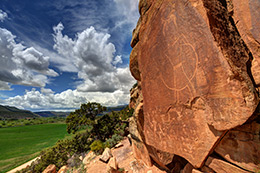
This small corner of southeastern Utah, has arguably the highest concentration of Anasazi sites anywhere. They aren’t the massive multi-room structures one finds in Mesa Verde, but what they lack in size they more than make up for in number. Literally hundreds of dwellings, granaries, and rock art panels can be found by those willing to put in the time and effort to find them. And unlike Mesa Verde, you won’t experience the crowds, and amusement park feel. This is a wilderness area, with the solitude, risks, and surprising discoveries that brings.

For convenience sake I am including in this region, Comb Ridge, Dark Canyon, Bears Ears, Montezuma Canyon, Natural Bridges NM, and of course Grand Gulch. All of these geographic areas are in relatively close proximity to each other, with Cedar Mesa the geographic epicenter of the group.

Prominent ruins in the area include: Moon House, House on Fire, Dollhouse, Jailhouse, Fallen Roof Ruin, Tower House, the Citadel, River House, Target (Bulls Eye), Honeycomb and Monarch Cave.

Hovenweep

While there is evidence of occupation by Paleoindians and Archaic Indians going back to 8,000 B.C., much of what is found at Hovenweep today is the ruins of 6 different Anasazi villages, protected  under several disconnected park units straddling the Utah/Colorado Border east of Cedar Mesa.   These units include – Cajon, Cutthroat, Goodman Point, Holly, Hackberry and Horseshoe and Square Tower, with Square Tower containing the largest concentration of ruins, and the location of the park visitor center.

— Colorado —

Colorado’s Anasazi ruins are concentrated in the state’s southwest corner, in the counties of Dolores and Montezuma.

Mesa Verde

Located in the Southwest corner of Colorado, just outside Cortez, Mesa Verde was without a doubt one of the two crowning architectural achievements (the other being Chaco Canyon) of the Anasazi. Contained within a series of canyons, these ruins represent the largest and best preserved examples of ancient Native American buildings, north of the Mexican border. Mesa Verde was a major settlement area for the Anasazi Indians between 650 A.D. and 1285 A.D. Cliff Palace, the largest of the dwellings contained at its height 150 rooms and 23 kivas, and housed an estimated 100 people.

At least 6 other major ruins are located in the park, with dozens of other sites within the canyons as well as the mesa top. These include Balcony, Long, Mug, Oak Tree, Spruce Tree and Square Tower Houses.

Mesa Verde NP: Website
Google Maps: Find
Flickr: Photo Gallery

Canyons of the Ancients National Monument

Canyons of the Ancients is similar to Cedar Mesa in its concentration of Anasazi ruins and wilderness character. Nearly 6000 archaeological sites have been recorded in the park, with 100 sites recorded per square mile in some locations. However most roads in the park are dirt, and there are very few trails or published details on minor ruins.

Prominent sites within the park include the Escalante and Dominguez Pueblos, located outside of Dolores, CO at the The Anasazi Heritage Center. The Pueblos are named after the Franciscan friars, Francisco Atanasio Domínguez and Silvestre Vélez de Escalante that discovered them during the Dominguez-Escalante Expedition in 1776. The pueblos were constructed from 1120-1130 A.D.

Another major site in the park, known as Lowry Pueblo (official website), was constructed in 1060 A.D., contained 40 rooms and multiple kivas. It is believed that at any given time it housed between 40-100 people, over the course of a 165 years.

All three of these pueblos show similar construction to the pueblos found in Chaco Canyon, in New Mexico.

Chimney Rock National Monument

Chimney Rock is an archaeological site in southwest Colorado. It is believed between 925-1125 A.D. it is believed as many as 2,000 ancient Pueblo Indians lived at the site. Housing approximately 2,000 ancient Pueblo Indians between A.D. 925 and 1125. One of the prominent features of the site  was the Great House Pueblo, which included two kivas, and 36 other rooms. Evidence suggests the Indians living at the site had linkages to the culture that built the Chaco Canyon site in central New Mexico.

 – Arizona –

Canyon De Chelly National Monument

Canyon de Chelly is a National Park wholly owned by and located within the Navajo Reservation. It is named after a particular canyon within the park but consists of three – de Chelly, del Muerto, and Monument. The canyon system is considered one the longest continuously inhabited locations in North America , mostly recently by the Navajo and Anasazi. Within the canyon are a number of visible Anasazi ruins, including White House, Antelope House and Sliding House. Of these three, park visitors can visit White House in the company of a Navajo guide.  In addition, over 2500 archaeological sites have been identified in the area, including dozens of Anasazi village sites.

Located in the Northeast corner of Arizona, it makes a good stop on a tour of other nearby archaeological sites, including Mesa Verde, Cedar Mesa and Chaco Canyon.

Google Maps – Find
Flickr: Photo Gallery

Wupatki National Monument

Wupatki National Monument is located in North Central Arizona near the town of Flagstaff. The park encloses archaeological sites from at least 3 distinct cultures, including the Cohonina, Kayenta Anasazi, and Sinagua. Wupatki Pueblo the ruin after which the monument is named is the oldest in the park and contained over 100 rooms. It also includes a ball court, a structure similar to those found in Mesoamerica, and suggestive of a link to tribes further south.

Google Maps – Find
Flickr: Photo Gallery

– New Mexico –

Aztec Ruins National Monument

Aztec Pueblo is a ruin of the ancient Anasazi that is over 900 year old and contained more than 400 rooms. the site also includes the largest reconstructed Kiva in the United States.  The ancient pueblo is located near the town of Aztec in northwest New Mexico near the town of Farmington in the Four Corners region.

Youtube: Virtual Tour of the Ruins

Chaco Canyon National Monument

Like Mesa Verde, Chaco Canyon’s 15 major archaeological sites are a product of the Ancestral Puebloeans. Located south of Mesa Verde in northern New Mexico, it contained the largest buildings in the United States until the 19th century. The largest of these, Pueblo Bonito, covers 3 acres and contains close to 800 rooms. However archaeological, and climatic research suggests that Chaco may have been intended more as a  gathering place for religious ceremonies, than an attempt to build a large permanent settlement. The design and alignment of many of the buildings suggest that solar and lunar cycles played a significant role in their construction. This importance is mirrored in the petroglyphs found in the area, including famously those on Fajada Butte.

Another notable feature of the Chaco Canyon site is the network of roads that radiate from it across the San Juan Basin. The longest of these are the Great North and South Roads. Debate continues about other significant road segments in the area that are shorter and disconnected, that absent weathering over time, may have been connected in the past. Whatever the case, they hint both at the importance of Chaco Canyon, but also the significant effort that was required to bring materials from other area, like timber, to build the canyon’s monumental architecture.
Google Maps: Find
Flickr: Photo Gallery
Archeoastronomy of the Chacoan Pueblo (PDF)

El Morro National Monument

A nice, partially reconstructed Anasazi pueblo exists atop the large sandstone promontory that marks this national historic monument. The site is known most prominently for the oasis it offered to travelers (from ancient puebloans to early pioneers) over the centuries, and who left behind evidence of their passing via a variety of elaborate inscriptions carved into the rock face.  A 2 mile loop trail leaves from the parking lot at the monument,  up to the top of the mesa and back down.

Top Pictograph/Petroglyph Sites in New Mexico

Comanche Gap Petroglyph / Jerry Willis

Comanche Gap Petroglyph / Jerry Willis

For rock art hunters, New Mexico offers a variety of locations to explore, some with petroglyphs numbering in the thousands over a very small area. Some locations are well known, while others take a significant effort in both time and research to find. And I like many avid rock art enthusiasts tend to keep the lesser known sites close to the vest. I do it for two reasons…half the fun is the research and discovery process. Nothing that is handed to you is as rewarding as finding it yourself. And second, there is little doubt that some among us hold this ancient art in less regard than others. Which has led to widespread vandalism of some of the more well known and easily accessible sites. That being said, there are plenty of publicly known locations to start your journey. And with a little effort you’ll find many more, some perhaps not seen by others in modern times.

Pictographs vs. Petroglyphs

What is the difference between a pictograph and petroglyph?. The answer lies in the tools used to create the art. Pictographs are essentially paintings, using varies pigments that produce different colors. Ochre was a widely used example that produces earthy shades of orange and red. But explore enough and you’ll find other colors like white, yellow, blue and green. On the other hand, Petroglyph were created by artists that used rocks and other blunt instruments to chip a design out of their sandstone canvas.

In my experience different tribes at different periods of time seemed to favor one style over the other. But it would be incorrect to say that pictographs were created by one group of Indians, and petroglyphs by another. As there example of both styles being used at the same time, and taking on the same artistic characteristics and subjects.

What is the rock art telling us?

At this point nobody knows precisely, and chance are good we never will. There is no equivalent to the Rosetta Stone in North American archaeology, and even if one were found, the rock art one finds in Utah and throughout the American Southwest is spread over such a vast period of time, and many different cultures that one translation wouldn’t fit them all.That being said, I don’t think we need to look farther than our own lives to get a sense of what the ancient Native Americans were recording in the sandstone. Like us they were human beings with aspirations, struggles, and questions about their place in the Universe.

If you look closely enough at the rock art and make some educated guesses you will see at this three different things.

The Natural World
There are repeated depictions of animals found in the real world. Bighorn sheep, snakes, buffalo, deer, elk and lizards. No doubt the Indians saw these as either a food source, a predator to be wary of, or both.  If you look at the Native American mythology of today you can also imagine these creatures taking on a spiritual or earthly mythological component. The oral traditions of the Raven and Coyote as a trickster that one sees in modern tribes is a good example.

The Spirit World
As noted above, there also seems to be a clear spiritual, or mythological component to the rock art that depicts creatures and anthropomorphic figures that are clearly not realistic representations of something found on Earth in the present or during the period ancient Indian tribes lived in the West. No doubt these creates find their origin in dreams, oral stories and spiritual beliefs about the world and the broader universe. Similar examples of such creatures can be found in the mythology of ancient Greece, the Norse, the Irish, etc.

The Celestial World
Finally, research has demonstrated that certain markings left behind were related to celestial events and observations. Such as arrows and other markers painted or carved onto rock faces where the sunlight only falls on key days of the astronomical calendar, such as the Summer and Winter Solstices, and the Spring and Fall Equinoxes. These markings alone tell us the Native Americans were keen observers of the night sky, and knew lunar, solar and constellation cycles well.

Popular New Mexico Rock Art Sites

Crow Canyon Petroglyphs (Dinétah Region Map)
The Crow Canyon Petroglyphs are located in Northwest New Mexico, near the Four Corners area, and the town of Farmington. The Petroglyphs are found in the traditional homeland of the Navajo, known as the Dinétah, and were largely carved by the Navajo between the 16th and 18th century. However, the rock art of the earlier Anasazi can also be seen.

The BLM recommends having a high-clearance, four-wheel drive vehicle to reach this site. Access is highly dependent on the weather, and requires crossing two washes that may be impassable in inclement weather. Drive south 19 miles from the junction of County Road 4450 and Highway 64. Follow the signs across Largo Wash, and then turn north and drive one mile to the mouth of Crow Canyon. Visit the Official Website.

Petroglyph Hill – Galisteo Basin

This is a petroglyph site outside of Galisteo, NM, that was purchased recently from the owners of the Thorton Ranch. Access to the site remains restricted but in recent years has been opened to guided public tours. Its estimated that over 2000 petrogylphs exist on this volcanic outcrop. A small fraction have been classified as Archaic, going back thousands of years, while the majority are believed to have been produced by New Mexico’s Puebloan peoples (1200-1325 A.D), in particular by a group that once inhabited the nearby Burnt Corn Pueblo archaeological site.

Another location related to this site, known as Comanche Gap (which remains closed to the public), offers some spectacular examples of the rock art produced by tribes in this area, and some of the best rock art examples I have seen in the Southwest.

La Cieneguilla Petroglyph (Location Map)
This petroglyph site is located just outside of Santa Fe New Mexico. Follow Airport Road 3.3 miles west from the intersection of Airport Road and NM Road 599. You will see a sign marking the location as well as a gravel parking lot. The petroglyphs are located on a basalt cliff face overlooking the Santa Fe River.

The rock art at this location has been attributed to the Keres Pueblo peoples and was carved between the 13th and 17th centuries, covering a time before and after their contact with the Spanish. This location is known for its large number of hump-backed flute player images (known popularly as Kokopelli). Birds are also a common theme among the petroglyphs.

An interesting side note of this location, is that it falls along the route of the El Camino Real de Tierra Adentro, an ancient trade route between Mexico and the Indian tribes of the southwest, that was later co-opted by the Spanish for their own purposes, including spreading Christianity across the region.

Mesa Prieta Petroglyph (Google Maps)
The 148 acre Wells Petroglyph Preserve was setup to protect a section of the petroglyph located on Mesa Prieta, in north central New Mexico. The petroglyphs are carved into a layer of 3 million year old basalt. A small number of the images can be attributed to archaic Indians, and typically appear as geometric patterns, or hand prints, but the vast majority of the rock art is attributed to Ancient Puebloans migrating into New Mexico from the Four Corners region. It’s estimated that more than 75,000 petroglyphs are located on the mesa.

Visiting the Wells Petroglyph Preserve requires setting up a tour with the Mesa Prieta Preservation Project, whose offices are located in Velarde, NM.

Three Rivers Petroglyphs – (Google Maps)
The site is located 17 miles north of Tularosa, NM, and 28 miles south of Carrizozo, NM on U.S. 54, in southeastern New Mexico. Turn east from U.S. 54 at Three Rivers onto County Road B30 and travel five miles on paved road, following signs.  According to the BLM these petroglyphs, depicting humans, reptiles, fish, mammals and insects were carved using stone tools by the Jornada Mogollon between 900 and 1400 A.D. The Mogollon were an Ancestral Puebloan people related to the modern Puebloan peoples of New Mexico (Hopi, Zuni, Keres, and Towa) as well as the Anasazi and Hohokam and Patayan.

It’s estimated the Three Rivers site contains more than 21,000 petroglyphs spread across 50 acres. Visit the Official Website.

Top Pictograph/Petroglyph Sites in Utah

McConkie Ranch Petroglyph - Utah

McConkie Ranch Petroglyph – Utah

For rock art hunters, Utah offers a veritable playground to explore, with hundreds, if not thousands of sites open to discovery. Some locations are well known, while others take a significant effort in both time and research to find. And I like many avid rock art enthusiats tend to keep the lesser known sites close to the vest. I do it for two reasons…half the fun is the research and discovery process. Nothing that is handed to you is as rewarding as finding it yourself. And second, there is little doubt that some among us hold this ancient art in less regard than others. Which has led to widespread vandalism of some of the more well known and easily accessible sites. With that, plenty can be said that will help those interested in exploring the wilds of Utah, and discovering a little bit of the history carved and painted on its sandstone walls.

Pictographs vs. Petroglyphs

What is the difference between a pictograph and petroglyph?. The answer lies in the tools used to create the art. Pictographs are essentially paintings, using varies pigments that produce different colors. Ochre was a widely used example that produces earthy shades of orange and red. But explore enough and you’ll find other colors like white, yellow, blue and green. On the other hand, Petroglyph were created by artists that used rocks and other blunt instruments to chip a design out of their sandstone canvas.

In my experience different tribes at different periods of time seemed to favor one style over the other. But it would be incorrect to say that pictographs were created by one group of Indians, and petroglyphs by another. As there example of both styles being used at the same time, and taking on the same artistic characteristics and subjects.

What is the rock art telling us?

At this point nobody knows precisely, and chance are good we never will. There is no equivalent to the Rosetta Stone in North American archaeology, and even if one were found, the rock art one finds in Utah and throughout the American Southwest is spread over such a vast period of time, and many different cultures that one translation wouldn’t fit them all.That being said, I don’t think we need to look farther than our own lives to get a sense of what the ancient Native Americans were recording in the sandstone. Like us they were human beings with aspirations, struggles, and questions about their place in the Universe.

If you look closely enough at the rock art and make some educated guesses you will see at least three different things.

The Natural World
There are repeated depictions of animals found in the real world. Bighorn sheep, snakes, buffalo, deer, elk and lizards. No doubt the Indians saw these as either a food source, a predator to be wary of, or both.  If you look at the Native American mythology of today you can also imagine these creatures taking on a spiritual or earthly mythological component. The oral traditions of the Raven and Coyote as a trickster that one sees in modern tribes is a good example.

The Spirit World
As noted above, there also seems to be a clear spiritual, or mythological component to the rock art that depicts creatures and anthropomorphic figures that are clearly not realistic representations of something found on Earth in the present or during the period ancient Indian tribes lived in the West. No doubt these creatures find their origin in dreams, oral stories and spiritual beliefs about the world and the broader universe. Similar examples of such creatures can be found in the mythology of ancient Greece, the Norse, the Irish, etc.

The Celestial World
Finally, research has demonstrated that certain markings left behind were related to celestial events and observations. Such as arrows and other markers painted or carved onto rock faces where the sunlight only falls on key days of the astronomical calendar, such as the Summer and Winter Solstices, and the Spring and Fall Equinoxes. These markings alone tell us the Native Americans were keen observers of the night sky, and knew lunar, solar and constellation cycles well.

Different Rock Art Styles/Traditions

At least three major groups were involved in producing the rock art found in Utah.

Archaic Indian Period (7500 B.C. to 300 A.D.?)
One of the major producers of pictograph rock art in Utah were a group of hunters and gathers known as Archaic Indians that lived in Utah from about 7500 B.C. until possibly as recent as 300 A.D. The art they left behind is known as the Barrier Canyon Style, whose name is derived from Barrier Canyon (now called Horseshoe Canyon) which lies to the west of Moab in an extension of Canyonlands National Park. Dating estimates for BCS seem to vary widely and are based on the difficult task of radiocarbon dating pigments and rock falls.

Fremont /Anasazi Indian Period (100 A.D.-1300 A.D.)

While the Fremont and the Anasazi were very distinct groups, they shared a number of similar characteristics, including a semi-nomadic lifestyle that incorporated village life and farming with active hunting and gathering. They also share a common time frame, which is why I group them together here. In general, I think it can be said that petroglyphs were there preferred form of expression, but pictographs including handprint displays have been attributed to them.

Ute Indian Period (1300 A.D. – 1880 A.D.)

The Ute Indian rock art is best distinguished from earlier art by the depiction of horses and their riders, as well as other more realistic depictions of animals, humans, etc. While horses were once native to North America they became extinct eons before humans arrived. Their depiction in recent petroglyphs provides a fairly precise date no earlier than the arrival of the Spanish, who were the first to bring horses back to the Western Hemisphere.

Popular Utah Rock Art Sites

Sego Canyon
I mention Sego Canyon first because its a bit unique in my experience, offering three distinct displays of rock art from the time periods described above. This allows the visitor to easily compare the different styles. Sego Canyon is located north of Moab and close to Utah’s border with Colorado off I-70. Just find Thompson Springs north of the highway, and follow its main road toward the Book Cliffs. Signs will direct you the rest of the way. Keep in mind that while part of the land containing petroglyphs is owned by the BLM, some are also on private land.

Horseshoe Canyon
This canyon contains what has been described as the “Michelangelo” of North American rock art – the Great Gallery. Within Horseshoe Canyon (once called Barrier Canyon) resides the largest and best-preserved examples of the Barrier Canyon Style, in a series of rock art panels. The Great Gallery the largest of the panels and over 200 feet in length, has anthropomorphs as tall as 7 feet and more than a half dozen of a similar height. The access point to Horseshoe Canyon is a dirt road on the opposite side of the highway from the entrance to Goblin Valley. Look for signs to Horseshoe Canyon. In dry weather, the road can be traveled by any well-maintained vehicle with proper precaution. The road is about 30 miles, and the hike into the canyon is 7 miles round trip. The best time to enter the canyon is in the early morning, this will help you to avoid most of the afternoon heat when you exit, and the sun should be in a good spot for photograph most of the panels.

McConkie Ranch (Dry Fork Canyon)
McConkie Ranch is to the Fremont Petroglyph legacy what Horseshoe Canyon was to the Archaic Indians. Hands down this along with Horseshoe Canyon are the most amazing petroglyph/pictograph sites I have ever visited. The petroglyphs are varied, detailed, pristine, and in some cases very large. However, unlike the other sites mentioned here, this one is entirely on private land, which for now remains open to those who respect the site and its owners. However, as was indicated to me that could change at any time. So if you haven’t been here before I highly recommend visiting sooner rather than later. And when you go, if you are lucky you might get to see their collection of arrowheads, spear points, baskets, and metates.

Newspaper Rock
Newspaper Rock is probably the best known and most widely photographed petroglyph panel in the United States. It features an array of different creatures, anthropomorphs, and symbols from a variety of different cultures. The Archaic Indians, Fremont, Anasazi, Navajo and other Ancestral Puebloan cultures have all visited the site and left their mark over the ages. This particular panel is located on the southern edge of Canyonlands, along SR211 which leads to the Needles section of the park.

Rochester Panel
This panel is mostly of Fremont origin but also displays art from other tribes, explorers, Mormon pioneers and unfortunately tourists. The acts of the latter though should not dissuade you from a visit,  as it is equal in caliber to Newspaper Rock in the amount and variety of art displayed in one spot. The panel is located just west of the San Rafael swell and east of the town of Emery.

Nine Mile Canyon
Nine Mile Canyon, located just north of Wellington in central Utah, was a vast artistic canvas for Fremont and Ute Indians. Its claim to fame is the sheer quantity of rock art that can be found along the canyon’s 46-mile length. To date over 1000 archaeological sites have been cataloged, including petroglyphs, dwelling ruins, and grain stores. Examples of rock art include – Big Buffalo, Mickey Mouse, The Great Hunt, and the Sand Hill Crane Panel.

Moab Area
A variety of rock art can be found close to Moab, most of it outside the boundaries of Canyonlands and Arches. Cultures represented in the different panels include the Archaic Indians, the Fremont, and Utes. Examples include Moab Man, Intestine Man, and Wolf Ranch

San Rafael Swell
The San Rafael Swell is a fairly vast area in central Utah and split by Interstate 70. While its known most for its amazing geologic display, it was also home to the Archaic and Fremont Indians. If you have the time and know how to survive Utah’s brutal desert conditions, this is one place that if you spend enough time you will likely find something few have ever seen. Well known rock art locations include – Molen Reef Snake, Buckhorn Wash, Head of Sinbad, and Black Dragon Wash.

McKee Springs (Dinosaur National Monument)
The McKee Springs petroglyphs have been attributed to the Fremont Indians, who lived in the park over a thousand years ago. To reach the petroglyphs requires travel north of the Park’s main Utah entrance, and entering via the Island Park Road. The road should be in good condition during dry weather, but it is primarily dirt.  The Island Park area is also known for remnants left behind by European pioneers and is an access point for boaters traveling on the Green River.

Suggested Reading:

A Field Guide to Rock Art Symbols of the Greater Southwest – Alex Patterson
Ancient Peoples of the Great Basin and Colorado Plateau – Steven R. Simms